
Delivery Information
E-commerce Products
The estimated delivery time varies by product. An estimated delivery time can be seen on the product page once you select "Delivery". This estimated delivery time is also confirmed throughout the checkout process.
Custom Products
Lead time varies depending on the product. Please request a quote to learn more.
If you have any questions about the status of your order, please contact us.
For step‑by‑step guidance on collecting your order, please refer to our Pick‑Up Guide
Unfortunately, we’re unable to deliver orders to PO Box addresses. Please ensure a physical street address is provided at checkout to avoid delays.
To update your delivery address, please call us on 1300 165 165 during our trading hours.
You can view our current trading hours below.
E-commerce Products
Delivery charges are calculated automatically and displayed at the checkout before you complete your order.
Custom Made Products
A member of our sales team will confirm the delivery charge with you prior to delivery.
Our deliveries are limited to the front of your property.
If you’re not home at the time of delivery, your order will be left safely at your property where appropriate.
If you have any specific delivery instructions or would like to discuss alternative options, please contact us on 1300 165 165 prior to delivery.
Timing
- We will endeavour to deliver your order on the confirmed delivery date.
- If there is a delay to your delivery, Statco will contact you to advise you.
- Some orders are delivered by third‑party courier services. While timely delivery is the aim, delays may occasionally occur. If your delivery does not arrive on the agreed‑upon date, please contact us for more information.
- If you need to change your delivery date, please contact our Customer Service Centre on 1300 165 165, speak with your trade representative, or visit your local Stratco store.
Arrival
- Where practicable, the driver will advise of arrival when the delivery is being made. If the site is unattended, the time of delivery will be recorded on the delivery documentation.
- Your order may be delivered by third party transport companies.
- Our deliveries are limited to the front of your property.
Unloading
- Our delivery drivers are trained in the safe handling and delivery of our products to help protect both people and materials. For everyone’s safety, they’re unable to accept assistance from others on site, as this can increase the risk of injury or product damage.
- We kindly ask that you allow the driver space to complete the delivery and observe from a safe distance. To ensure a safe environment, please also keep children and pets well clear of the delivery vehicle during the delivery process.
Split Deliveries
- Your consignment may come from different locations therefore your shipments may arrive at different times. To find out about your order, please contact us.
Issues
- If you experience any issues with your delivery, please feel free to contact us for assistance. To help us resolve the matter promptly, please have your order number available.
- In the event that we have attempted to deliver your item and failed, please contact our customer service team on 1300 165 165 with your order number and they would be able to help you trace your order.
Large Deliveries
- Special handling may be required for large and oversized items being delivered to customers. In some occasions, we may delivery using a crane or heavier items may be delivered on pallets. Please refer to the delivery instructions that you were given at the time of your order. If you have any inquiries, please contact us.
Picking Up From a Stratco Site
- Before picking up your order from a Stratco site, please review the safety guide below to help keep everyone safe.
Still have questions about your delivery?
Delivery Zones and Schedules
| Delivery Schedule | ||
| Area 1 | Sydney Metro | Daily |
|---|---|---|
| Area 2 | Central Coast | Daily |
| Area 3 | The Blue Mountains | Tuesdays, Thursdays |
| Area 4 | Newcastle and Hunter Valley | Daily |
| Hunter Valley to Muswellbrook | Tuesdays, Thursdays | |
| Mid Coast to Taree | Wednesdays | |
| Area 5 | Mid South Coast | Daily |
| Area 6 | Southern Highlands | Daily |
| Area 7 | South Coast | Tuesdays, Fridays |
| Area 8 | ACT, Queanbeyan | Daily |
| Area 9 | Goulburn | Mondays, Wednesdays, Fridays |
| Area 10 | Crookwell | Wednesdays |
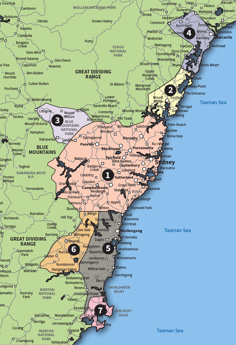
(Areas 8, 9 and 10 are not shown on the map)
Boundary Points
AREA 1
Bound by the Hawkesbury River in the north, the Nepean River in the west (including Great Western Highway to Katoomba) and by a line drawn to join The Oaks to Helensburg in the south.
AREA 2
Bound by Budgewoi in the north, and then by a line drawn to join Dooralong to Peats Ridge in the west, and the Hawkesbury River in the south.
AREA 3
Towns along the Great Western Highway from Katoomba to Lithgow.
AREA 4
Bound by the Hunter River in the north to Nelson Bay, Maitland, Braxton, Cessnock and south to Budgewoi.
AREA 5
Bound by Helensburg in the north and ciries and townships along the Pacific Highway south to South Nowra.
AREA 6
Hume Highway from Picton south to Buxton, Bargo, Mittagong, Bowral, Mossvale and Bundanoon.
AREA 7
Bound by South Nowra in the north and cities and townshipd along the Pacific Highway south to St. Georges Basin.
AREA 8
ACT - Bound by Bonner in the north, Duffy in the west, Jerraboberra in the east and Banks in the south. Queanbeyan - An area within 5km radius of central Queanbeyan.
AREA 9
An area within 20km radius of central Goulburn and townships along the Federal/Hume Highway south of Goulburn.
AREA 10
An area within 20km radius of central Crookwell and townships along Crookwell Road between Goulburn and Crookwell.
| Delivery Schedule | |
| Area 1 | Daily |
|---|---|
| Area 2 | Daily |
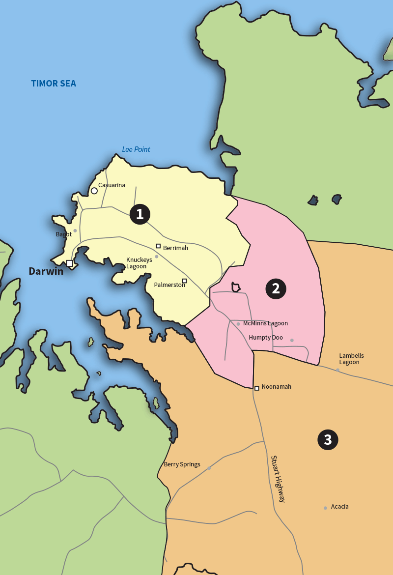
Boundary Points
AREA 1
North of Coolinga Shopping Centre.
AREA 2
South of Coolinga Shopping Centre as far as Arnhem Highway.
AREA 3
South of Arnhem Highway.
| Delivery Schedule | ||
| Areas: | 1, 2, 4, 6, 8 | Daily |
|---|---|---|
| Area 3 | Hinterland | Tuesdays, Thursdays |
| Area 5 | Noosa to Gympie | Mondays, Thursdays |
| Area 7 | Northern Rivers Hinterland | Mondays, Thursdays |
| Area 9 | West of Toowoomba | Wednesdays, Fridays |
| Area 10 | Toowoomba to Warwick | Tuesdays, Thursdays |
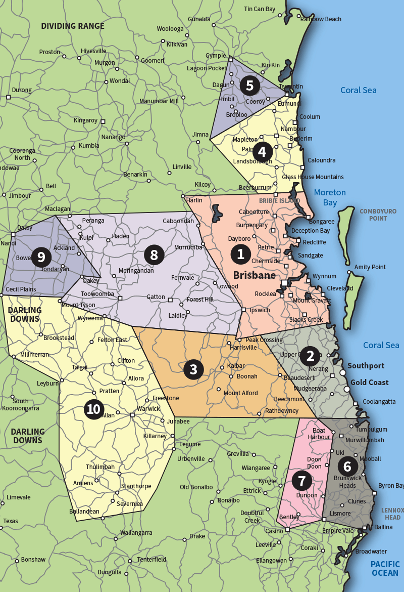
NOTE: Weekly run south from Warick to Tenterfield is also available.
Boundary Points
AREA 1
Bound by Yatala in the south, Caboolture River in the north and Ipswich in the west.
AREA 2
Bound by Yatala in the north, Tweed River in the south and Canungra to the west.
AREA 3
Bound by Peak Crossing in the north, Rathdowney and Springbrook in the south, Yangan and Fordsdale in the west.
AREA 4
Bound by Caboolture River, Kenilworth in the west and Tewantin in the north.
AREA 5
Bound by Tewantin in the south and Kenilworth in the west and Gympie in the north.
AREA 6
Bound by the Tweed River in the north, Murwillumbah in the west and Lismore and Ballina in the south.
AREA 7
Bound by Murwillumbah in the east and Lismore and Casino in the south, Kyogle in the west and Rathdowney in the north.
AREA 8
Bound by Ipswich in the east, Peak Crossing in the south, Caboonbah and Haden in the north, and MtTyson in the west.
AREA 9
Mt Tyson in the south and Cecil Plains and Dalby in the west, Oakey and Moola in the east.
AREA 10
Cecil Plains and Millmerran in the west, Stanthorpe in the south, Yangan to Fordsdale in the east.
| Delivery Schedule | ||
| Area 1 | Metropolitan | Daily |
|---|---|---|
| Area 2 | Outer Metropolitan | Daily |
| Area 3 | Murraylands | Tuesdays, Thursdays |
| Area 4 | Fleurieu | Fridays |
| Area 5 | Langhorne Creek | Thursdays |
| Area 6 | Riverland | Mondays, Wednesdays, Fridays |
| Area 7 | Copper Triangle | Tuesdays, Thursdays |
| Area 8 | Port Lincoln | Mondays, Thursdays |
| Area 9 | Clare | Wednesdays |
| Area 10 | Port Pirie | Thursdays |
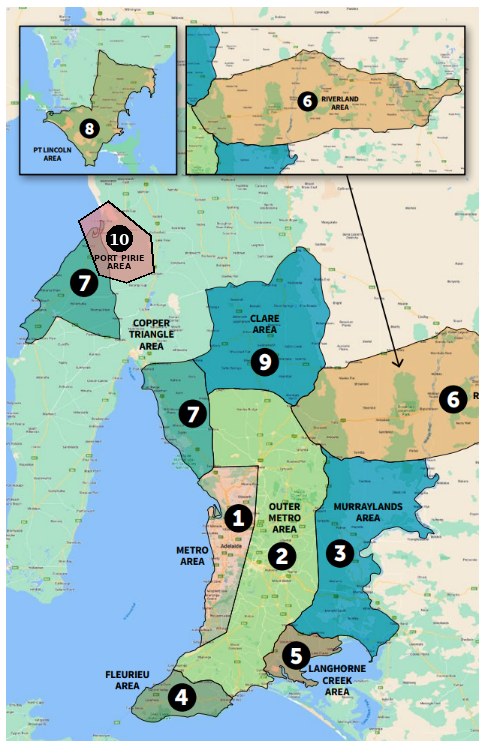
Boundary Points
AREA 1 - The Metropolitan Area
Bound by Two Wells and Port Gawler in the north and from there by a line drawn to connect Willaston, Tea Tree Gully, Clarendon, Willunga and Sellicks Beach.
AREA 2 - Outer Metropolitan Area
Bound by a line drawn to connect Pinery, Owen, Alma, Tarlee, Kapunda, Angaston, Eden Valley, Mount Pleasant, Harrogate, Callington and Strathalbyn to Goolwa via the Strathalbyn to Goolwa Road, along the south coast to Victor Harbor, Encounter Bay and across to Yankalilla and Normanville.
AREA 3 - The Murrraylands
Bound by a line drawn to connect Strathalbyn, Callington, Mt Pleasant along the Eden Valley Road to Angaston. East along the Angaston-Swan Reach Road to Swan Reach then following the Murray River south to Murray Bridge. Along the Princes Highway to Tailem Bend then south to the Wellington turn off, west back along the Langhorne Creek Road to Strathalbyn.
AREA 4 - The Fleurieu Area
Bound by Encounter Bay, Yankalilla and Normanville.
AREA 5 - The Langhorne Creek Area
Bound by a line to connect Goolwa, Currency Creek and Strathalbyn. East along Langhorne Creek Road. South down Lakes Plains Road to Lake Alexandrina, then follow the banks of Lake Alexandrina back to Goolwa.
AREA 6 - The Riverland Area
Bound by the Thiele Highway from Kapunda to Morgan then north of the River Murray on the Goyder Highway through Taylorville, Overland Corner to Monash. Then following the Sturt Highway into Renmark then across the river to Paringa and Wonuarra. South along Stanitzki Road to Bookpurnong Road, then south along to Bookpurnong Road to Loxton continuing onto Kingston Road to Stott Highway. West along the Stott Highway through to Swan Reach, Sedan and Angaston across to Kapunda.
AREA 7 - The Copper Triangle
Bound by the coast from Middle Beach up to Port Wakefield along the Copper Highway through Kulpara, Paskerville, Thrington to Kadina. Down the Moonta-Kadina Road to Moonta across to Port Hughes then up the coast taking in Moonta Bay, Wallaroo, Tickera to Port Broughton and Fishermans Bay. South down the Upper Yorkes Road to Bute onto Kulpara. Continue south on the Copper Coast Highway to Port Wakefield, west on Bowmans Road to Balaklava. Then south down Traeger Road to Mallala continuing onto Mallala Road to Two Wells.
AREA 8 - The Port Lincoln Area
Bound by the Lincoln Highway in the east connecting Tumby Bay and Port Lincoln, along the coast in the south to Coffin Bay in the west, north via the Tod Highway to Cummins and returning to Tumby Bay along Bratten Way
AREA 9 - The Clare Area
Bound by Pinery and Balaklava in the west up to Halbury then up to Armagh in the north, across to the east through Clare to Farrell Flat. Then north to Burra following the Goyder Highway to the Worlds End Highway through Roberstown to Eudunda. Follow the Eudunda Road back towards Kapunda west to Tarlee, Alma, and Pinery.
AREA 10 - The Port Pirie
Bound by a line drawn from Port Pirie southwest to Port Davis, then following the Spencer Gulf coast south through Fisherman Bay and Port Broughton. From there, east to Mundoora, northeast to Redhill, north along the Augusta Highway to Crystal Brook, then northwest back to Port Pirie.
| General Delivery Schedule | |
| Areas 1-4 | Daily |
|---|---|
| Area 5 | Thursdays |
| Area 6 | Tuesdays, Fridays |
| Areas 1-2 | Mondays, Wednesdays |
|---|---|
| Areas 3-4 | Tuesdays, Thursdays, Fridays |
| Area 5 | Thurdays |
| Areas 5 | Mondays |
| Garden Shed Delivery Schedule | |
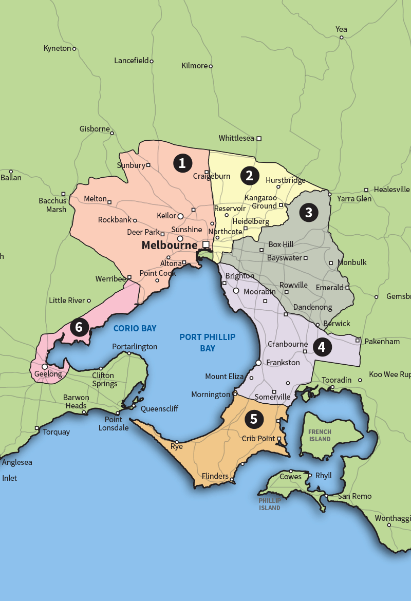
Boundary Points
AREA 1
Bound by the following suburbs and towns: Werribee, Wyndham Vale, Bacchus Marsh, Melton, Sunbury and Mickleham then via Donnybrook Road and Hume Freeway to Epping.
AREA 2
Bound by the following suburbs and towns: Hume Freeway to Donnybrook Road, Whittlesea, St Andrews, Yara Glenn, Ringwood, Bulleen and Kew.
AREA 3
Bound by the following suburbs and towns: Eastern Freeway, Balwyn North, Blackburn North, Ringwood, Lillydale, Montrose, The Basin, Belgrave, Narre Warren North, Monash/Princess Freeway.
AREA 4
Bound by the following suburbs and towns: Monash/Princess Freeway to Pakenham, then via Ballarto Road to Cranbourne South, Langwarrin and Frankston.
AREA 5
Bound by the following suburbs and towns: Frankston, Portsea, Balnarring, Hastings, Tyabb and Pearcedale.
AREA 6
Bound by the following suburbs/towns: Werribee, Lara, Geelong, Waurn Ponds and Moolap.
| Delivery Schedule | ||
| Area 1 | Metropolitan | Daily |
|---|---|---|
| Area 2 | Near Country | |
| North | Tuesdays, Thursdays | |
| South Coast | Daily | |
| South Central | Fridays | |
| Area 3 | Far Country | |
| South Coast | Tuesdays, Fridays | |
| South Central | Thursdays | |
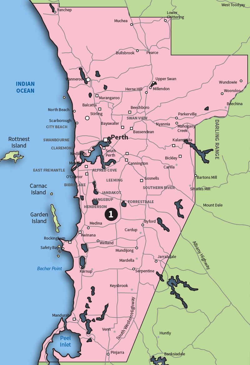
(Areas 2 and 3 are not shown on the map)
Boundary Points
AREA 1
North - Two Rocks and Chittering.
East - Pinjarra, Hill Top Line, Mundaring, Wundowie and Chittering.
South - Bouvard and Pinjarra.
AREA 2
North - Lancelin, Gin Gin, Northam and York.
South Coast - Bunbury, Busselton, Collie, Mumballup, Capel and Donnybrook.
South Central - Narrogin, Wagin, Arthur River and Williams.
AREA 3
South Coast - Dunsborough and Margaret River.
South Central - Kirup, Mullalyup, Balingup, Greenbushes, Boyup Brook, Bridgetown and Nannup.
